Coast to coast..... and return back home!
Today I woke up early and refreshed at Lovelock......and so did O.J. Simpson. The only difference is that I woke up at the Cadillac Inn, and he woke up at the local penitentiary. Apparently this is where he is currently serving his sentence, as I learned this morning.
The plan for today was to fly to the Carson Valley, then to lake Tahoe and South Lake Tahoe town and from there direct to Palo Alto. And it just happened as planned.
Below some pictures along the route:
This is the Cadillac Inn, a modest but squeaky clean Motel in downtown Lovelock where I spent the night. (Picture taken from my room; #12)
This is Larry, the Motel owner. He and his wife are great folks who used to live in California and moved to Nevada. They run several Motels in town. He likes to repair Ford T's and took some flight lessons in the Clearlake area.
After take off I have a final look at the airport (See in the middle of the pic). Larry has told me that sometimes the whole valley is flooded and the airport cannot be used. The river that feeds this area is the Humboldt and disappears as it reaches the valley.
The valley further ahead and ranges of mountains in the distance.
A Raceway track somewhere around Silver Springs.
Reno in the distance.
Arriving over Carson city and the Carson valley.
Finally the beautiful lake Tahoe is at view as I climb to 10,500 ft.
So beautiful and blue. The snow across the lake is Squaw Valley.
A view towards the North area of lake Tahoe.
Notice the different elevation of the Carson valley on the left side and Tahoe lake on the right.
A last view of the Carson valley to see Minden and its airport. One of the best places in the world for soaring.
One has to watch for gliders when flying in this area, but not today. It is too soon for thermal activity, and there's no wave.
The east side of lake Tahoe (the closest one in this picture) is in Nevada and the west side in California.
The Ski Resort of Heavenly ahead of me.
The South shores of lake Tahoe. Not easy to see but in the distance a hint of Emerald Bay, the pearl of Tahoe.
Another view of the town of South lake Tahoe.
And another one.
And yet another one.
This is another lake; Fallen Leaf lake, which is next to lake Tahoe.
Here you can see Fallen Leaf and Tahoe lakes together.
The Echo lakes. This is a great place for hiking; whether in Summer or in Winter.
Another perspective on this beautiful area.
On my right side another Ski Station. (Sierra resort, I believe)
Some cascades in the distance.
Leaving the high terrain, a lake in the distance. Probably the Wrights lake.
A clear in the woods.
First town as I descend to the Sierra foothills: Jackson with Amador Co. airport.
These are the views of California valleys. I already feel at home.
Camanche Reservoir
More valley views.
Los Vaqueros reservoir next to Byron airport and the eolic parks. I am so close to home!
This picture in honor of Roswita and Gerd. Looking to Mount Diablo. The Hidden valley where they live is close to it.
The California typical golden rolling hills with oak trees as I approach Fremont.
Some red ponds as I reach the San Francisco Bay. I am literally minutes away from landing in Palo Alto, after I left about 2 weeks ago.
Finally I hear: N669TW, CLEAR TO LAND in PALO ALTO !
Wait a minute! This does not look like Palo Alto.
In my absence they have re-paved and re-painted the runway. Nice!
Maite and Julia are here to receive me ! Awesome! I can't wait to give them a BIG HUG!
My track log today from Lovelock, Nevada to Palo Alto, California (KLOL-KPAO)
Totals of the day:
- 239 nm
- 2 hours, 34 minutes
Trip Totals and Routes:
Nautical Miles
- From Palo Alto, CA to Kitty Hawk, NC (Southern route): about 2,503 nm
KPAO - KWJF - KSEZ - KSVC - KHOB - KACT - KMEI - KLGC - KTTA - KFFA - KMQI
- From Kitty Hawk, NC to Palo Alto, CA: (Northern route): about 2,285 nm
KMQI - KROA - KBKW - KMVN - KBIE - KBFF - KRKS - KOGD - KENV - KEKO - KLOL -KPAO
Total Trip: about 4,788 nm (~8867 Km)
My track East:
My track West:
Flying Time
Total way East: 24,9 hours
Total way West: 25 hours
Total flying hours: 49.9
Trip duration: ~ 16 days
-Left Palo Alto on Thursday, April 16 at around 7AM
-Arrived to Kitty Hawk on April 22 at around 11AM
-Arrived back to Palo Alto on Friday, May 1 at around 11AM
I flew over 21 States:
California, Arizona, New Mexico, Texas, Loiusiana, Mississippi, Alabama, Georgia, South Carolina, North Carolina, Virginia, West Virginia, Kentucky, Indiana, Ilinois, Missouri, Iowa, Nebraska, Wyoming, Utah and Nevada
I stopped at 14 States:
California, Arizona, New Mexico, Texas, Mississippi, Georgia, North Carolina, Virginia, West Virginia, Illinois, Nebraska, Wyoming, Utah and Nevada
......OK, this was a very challenging objective. And it has become a FANTASTIC ADVENTURE. I have enjoyed it a lot and learned much in the process. What else can I ask for?
All the best to all who where there with me in this adventure, this is part of us now. I am happy if you enjoyed it too....... and now....... until the next one!
Eduair :-)
Eduard Gorina
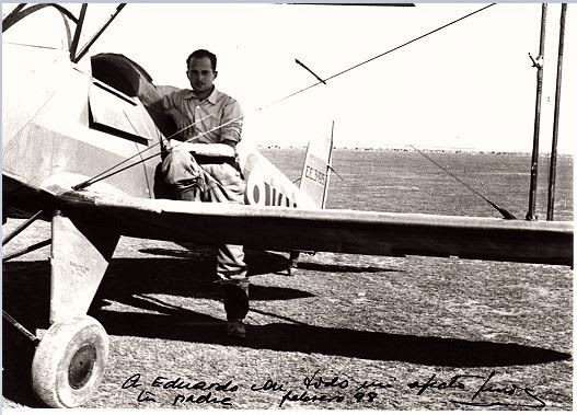
Dedicated to my father who planted the seed for flying in me at a young age:
Lluis Gorina Batista with his airplane in Villafria, Burgos, Spain 1945


 The Town of Fernley and the Reno valley behind.


