Friday, May 1, 2015

BACK HOME!


Coast to coast..... and return back home! 


Today I woke up early and refreshed at Lovelock......and so did O.J. Simpson. The only difference is that I woke up at the Cadillac Inn, and he woke up at the local penitentiary. Apparently this is where he is currently serving his sentence, as I learned this morning.

The plan for today was to fly to the Carson Valley, then to lake Tahoe and South Lake Tahoe town and from there direct to Palo Alto.  And it just happened as planned.

Below some pictures along the route:


This is the Cadillac Inn, a modest but squeaky clean Motel in downtown Lovelock where I spent the night. (Picture taken from my room; #12)


This is Larry, the Motel owner. He and his wife are great folks who used to live in California and moved to Nevada. They run several Motels in town. He likes to repair Ford T's and took some flight lessons in the Clearlake area.

 After take off I have a final look at the airport (See in the middle of the pic). Larry has told me that sometimes the whole valley is flooded and the airport cannot be used. The river that feeds this area is the Humboldt and disappears as it reaches the valley.


The valley further ahead and ranges of mountains in the distance.


A Raceway track somewhere around Silver Springs.


 Reno in the distance.


 Arriving over Carson city and the Carson valley.


Finally the beautiful lake Tahoe is at view as I climb to 10,500 ft.


So beautiful and blue. The snow across the lake is Squaw Valley.


A view towards the North area of lake Tahoe.


Notice the different elevation of the Carson valley on the left side and Tahoe lake on the right.


A last view of the Carson valley to see Minden and its airport. One of the best places in the world for soaring.
One has to watch for gliders when flying in this area, but not today. It is too soon for thermal activity, and there's no wave.


 The east side of lake Tahoe (the closest one in this picture) is in Nevada and the west side in California.


The Ski Resort of Heavenly ahead of me.


The South shores of lake Tahoe.  Not easy to see but in the distance a hint of Emerald Bay, the pearl of Tahoe.


Another view of the town of South lake Tahoe.


And another one.


And yet another one.


This is another lake; Fallen Leaf lake, which is next to lake Tahoe.


Here you can see Fallen Leaf and Tahoe lakes together.


The Echo lakes. This is a great place for hiking; whether in Summer or in Winter.


Another perspective on this beautiful area.


On my right side another Ski Station. (Sierra resort, I believe)


Some cascades in the distance.


Leaving the high terrain, a lake in the distance. Probably the Wrights lake.


A clear in the woods.


First town as I descend to the Sierra foothills: Jackson with Amador Co. airport.


 These are the views of California valleys. I already feel at home.


Camanche Reservoir


More valley views.


Los Vaqueros reservoir next to Byron airport and the eolic parks.  I am so close to home!


This picture in honor of Roswita and Gerd. Looking to Mount Diablo. The Hidden valley where they live is close to it.


The California typical golden rolling hills with oak trees as I approach Fremont.


Some red ponds as I reach the San Francisco Bay. I am literally minutes away from landing in Palo Alto, after I left about 2 weeks ago.


Finally I hear:  N669TW,  CLEAR TO LAND in PALO ALTO !


Wait a minute! This does not look like Palo Alto.
In my absence they have re-paved and re-painted the runway. Nice!


Maite and Julia are here to receive me ! Awesome! I can't wait to give them a BIG HUG!


My track log today from Lovelock, Nevada to Palo Alto, California  (KLOL-KPAO)


Totals of the day:

  • 239 nm
  • 2 hours, 34 minutes


Trip Totals and Routes: 

Nautical Miles 
- From Palo Alto, CA to Kitty Hawk, NC (Southern route): about 2,503 nm
KPAO - KWJF - KSEZ - KSVC - KHOB - KACT - KMEI - KLGC - KTTA - KFFA - KMQI

- From Kitty Hawk, NC to Palo Alto, CA: (Northern route): about 2,285 nm
KMQI - KROA - KBKW - KMVN - KBIE - KBFF - KRKS - KOGD - KENV - KEKO - KLOL -KPAO

Total Trip: about 4,788 nm  (~8867 Km)

My track East:


My track West:


Flying Time
Total way East: 24,9 hours
Total way West: 25 hours

Total flying hours: 49.9

Trip duration: ~ 16 days


-Left Palo Alto on Thursday, April 16 at around 7AM
-Arrived to Kitty Hawk on April 22 at around 11AM
-Arrived back to Palo Alto on Friday, May 1 at around 11AM


I flew over 21 States:
California, Arizona, New Mexico, Texas, Loiusiana, Mississippi, Alabama, Georgia, South Carolina, North Carolina, Virginia, West Virginia, Kentucky, Indiana, Ilinois, Missouri, Iowa, Nebraska, Wyoming, Utah and Nevada

I stopped at 14 States:
California, Arizona, New Mexico, Texas, Mississippi, Georgia, North Carolina, Virginia, West Virginia, Illinois, Nebraska, Wyoming, Utah and Nevada

......OK, this was a very challenging objective. And it has become a FANTASTIC ADVENTURE.  I have enjoyed it a lot and learned much in the process. What else can I ask for? 

All the best to all who where there with me in this adventure, this is part of us now. I am happy if you enjoyed it too....... and now....... until the next one!

Eduair :-) 

Eduard Gorina


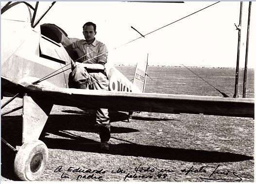
Dedicated to my father who planted the seed for flying in me at a young age:


Lluis Gorina Batista with his airplane in Villafria, Burgos, Spain 1945


Thursday, April 30, 2015

All Starts to Feel Familiar Again


Hello. I am in Lovelock! Yes, in Lovelock Nevada a ~2000 inhabitants town in the Nevada high plains, at 3,907 ft.

The most delicate point today was exiting Ogden to the South West. Why? Because there's a big lake (The Salt Lake) and there are plenty of military areas in the vicinity (See pics below). Also the radar showed rain right in my corridor. Later I confirmed that this rain although real it does not reach the ground. It is called "virga". (See pic below)

After that all was about negotiating mountains and the best winds. After 3 days of headwind today I had some tailwind! Not much, but it is always appreciated. I finally landed in Lovelock for the simple reason that it sets me up for a relatively short final leg back to Palo Alto, back home.
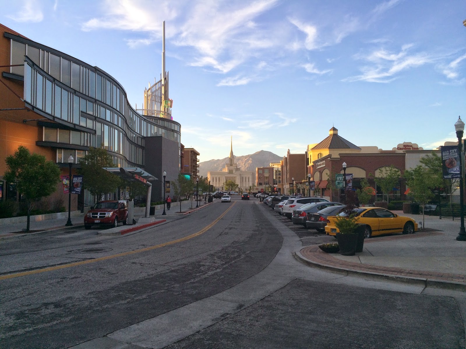
As I could experience yesterday Ogden is a city plenty of attractions, confirming what I was told.
I had a delicious BLT salad with avocado and a Honey beer at Rooster on the 25th, which is a street plenty of cafes and restaurants. Then I had some time to wander around and found among other things two very cool activities; Indoor skydiving and indoor surf (See below).


Town with all the advantages of Salt Lake city but none of the disadvantages of a big city. Good temperatures and snowed mountains in the background.


If you want to attend the Ogden Pioneer Rodeo, you are still on time.
Just reserve some days in July.


Nice walkable avenues with restaurants, cafes and outdoor and indoor activities as the day dies out with warm colors.


There it is: the indoor skydiving place. For $55 you can experience 2 minutes of skydiving in full safety without leaving the earth. (And even needing a parachute)


The pics are not very good, but here you can see some parachute-less skydivers "floating" in this vertical wind tunnel and performing all types of acrobacies.

It was noisy, but very intense. They would not just stay level, they would go up and down and around. Sometimes they would hit the glass walls.


 Here the indoor Surf. Very funny and ingenious! The prices were ~$30 an hour.
What do you prefer? Surf or Skydive?


This is what I was mentioning at the beginning about exiting the Ogden area to the South West. This was my final selected route. Avoiding Class Delta, crossing the lake and heading west parallel to I-80.  As you can see there are 2 areas that say Air Force, and only one corridor in between.


All this is better appreciated in the aeronautical chart below: (Same area but with all the additional aeronautical information)


This is Antelope Island, which is also a State Park. It is worth visiting. I spent some time with Maite and Julia when we last visited the area, and even adventured ourselves in the salty waters on those beaches.


Arriving at the other side of the lake.


Salty and sandy terrain which probably long ago was also covered by water.


This picture has more than it appears; This are the Bonneville Salt Flats. Remember the movie "The world fastest Indian"? by Anthony Hopkins....? .... where he beats the land-speed world record riding a motorcycle?  Well, all this happened here in 1967.  Many other speed records have been attempted and beat since then in these same flats....


These are the cloud producing rain that the radar was detecting. Only that the rain evaporates well before it reaches the ground. This picture is not perfect but we can appreciate this effect.


More clouds with precipitation in the mid distance and vasts extensions of high level desert.


Here I am crossing a range of snowy mountains. Obviously I selected the lower section.


Another range of mountains with snow.


Details of the pass as I fly over it.


For a while I was parallel to this majestic mountain range.


Here we can appreciate the old and the new I-80 routes with a tunnel.


This is the famous S mountain. Unique in the world and part of the known universe.


The selfie of the day.   :-)


Nothing special, just lower mountains as I pass range after range after range....


View on my right side as I head south west and getting closer to my destination today.


Following 3 pictures about how it feels to land at Lovelock (K-LOL) 
No one to be heard on the radio during the traffic announcements. It seems an empty place.


Can you see the runway? 


 Touchdown !  (Very gentle, i promise. Despite the 14 kt with 20 gusts winds)


The Parking lot. Only one airplane, and it is a Cessna-cousin! 


Nobody to greet me but a sign stating all I could find in there. All was true. The door was open, and I could use the pilots room, the restrooms, the telephone to call to one of the recommended Motels on the list with comments and I refueled in the self service, so that the airplane is ready tomorrow morning. 
(Yes, Lovelock airport is also known as Derby Field, and KLOL) 


Nobody around. Literally. So I take another picture with the "tower" and N669TW.


 An airplane that looks like a Mig-3 (?)  No one to tell the story behind this plane...... and I am sure there is one.


By now I am already in my Motel room writing these lines. The owner of the Cadillac Inn came to get me and will bring me back here again tomorrow for a modest fee.


My track today:

From Ogden, Utah to Lovelock, Nevada  (KOGD-KLOL)


The Day Totals:

  • 318 nm
  • 3 hours, 5 minutes 
(Finally a little bit of tailwind!)


Well on my way back home!  Only a 2.5 hours leg away from Palo Alto!  

I can't wait to meet Julia and Maite who have promised to come to the airport.

All the best form Lovelock, Nevada.

Eduair   ;-)